 Pierre Dubeau, Carleton Geography and Environmental Studies MSc student, uses high tech remote sensing imagery and community-based field work to examine the environmental and socio-economic importance of wetlands for Ethiopian’s rural society.
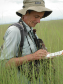
Pierre Dubeau is conducting his Masters research on the role and importance of key wetlands in the Ethiopian Highlands, which are part of the Nile Basin. In this project, he is engaging with wetland ecologists at Addis Ababa University, the International Water Management Institute (IWMI) and local community members to map wetland vegetation and seasonal dynamics in relation to the agricultural land use needs of the local communities.
Wetlands play a vital role in maintaining access to water and pastoral lands for the large rural population in Ethiopia. Portions of the wetlands support vast areas of grasslands, which are extensively grazed during the dry season. However, there is very little geo-spatial information describing their size, distribution, and seasonal dynamics. Pierre’s MSc research will use remote sensing technologies to provide up-to-date spatial and temporal information about the wetlands and their catchment basins, which can aid local wetland land use management practices and broader waterresources management of the Nile Basin.
His project is supervised by Doug King, co-director of Carleton’s Geomatics and Landscape Ecology, and supported by the Japanese Aerospace Exploration Agency (JAXA) through IWMI. Radar and visible-near infrared satellite images of the wetlands were acquired using this support under the Wetland Theme of the JAXA’s Advanced Land Observing System (ALOS) Kyoto Carbon Initiative.
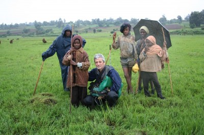
Since 2009, Pierre has returned to Ethiopia every year to carry out field research to gain an understanding of the wetland ecology and the socio-economic importance of the wetlands. The field work engages local community members and includes field mapping for validation of the wetland maps derived from the remotely sensed imagery. Pierre believes that engagement with the community, dissemination of his up-to-date wetland maps, and demonstration that this information can be produced in the future at low cost by local government agencies will help improve the conservation and management of wetlands that are under extreme pressure from human development.
Note: This story is courtesy of the January 2013 issue of the gLoeb Xpress, the newsletter produced by the Department of Geography and Environmental Studies.
Thursday, January 10, 2013 in Grad Student Research
Share: Twitter, Facebook


